History
Satellite laser ranging at GGAO
Satellite laser ranging (SLR) systems at GGAO have provided a continuous set of SLR data since 1964. GGAO is the birthplace of the world's first satellite laser ranging system, Goddard Laser (GODLAS), which became operational May 5, 1964. The knowledge gained from GODLAS spawned a new breed of laser system, the Mobile Laser System (MOBLAS). During the next fifteen years, the second and third generation MOBLAS systems were developed at GGAO and deployed to locations around the world. By 1985, the NASA Satellite Laser Ranging network of eight MOBLAS systems and four transportable laser ranging systems (TLRS) were operational as part of NASA's Crustal Dynamics Project (CDP) making scientific measurements including the determination of the movement of the Earth's tectonic plates.
Instruments
- SGSLR
SGSLR at GGAO
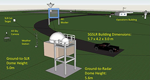
The Space Geodesy Satellite Laser Ranging (SGSLR) systems are based upon the NGSLR prototype system developed at NASA GSFC and tested at GGAO. SGSLR is a single photon detection system using a high repetition rate laser with common optics, aggressive noise rejection, a shared aperture approach to separation of transmit and receive light, point-ahead transmit optics, transmit and receive pulse collision rejection, and a high precision tracking mount. SGSLR is designed to be fully automated, but full automation may not be realized due to the FAA requirement for a human to re-enable the laser after laser disable due to the radar sensing of an aircraft (which may not be required for international sites).
- MOBLAS-7 SLR system, one of the most accurate SLR system in the world. This SLR system is part of the International Laser Ranging Service (ILRS) network, whose primary mission is to support, through satellite and lunar laser tracking data and related products, geodetic and geophysical research activities. The MOBLAS-7 system has operated at GGAO since 1981.

MOBLAS-7 at GGAO
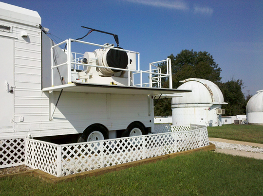
MOBLAS-7 is stationed at GGAO to perform three vital NASA SLR functions: (1) to collect important data on the movement of the North American plate, (2) to serve as a test bed for the implementation of the latest improvements in laser ranging technology, and (3) to serve as a network standard in special collocation tests which compare the performance of new or upgraded systems before they are sent into the field as operational systems.
The MOBLAS-7 system is comprised of three vans that contain various components of the system. Electronics and computer systems required by MOBLAS-7 for targeting, data processing, etc. are located in the vans. Radar systems to detect aircraft flying in the area are mounted on the other two vans.
- NASA’s prototype Next Generation Satellite Laser Ranging System (NGSLR), formerly known as SLR2000, was built to demonstrate that a system using existing Commercial off-the-shelf (COTS) technology can satisfy the performance requirements as an autonomous and eye-safe photon-counting SLR station with normal point precision at the mm level.
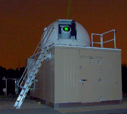
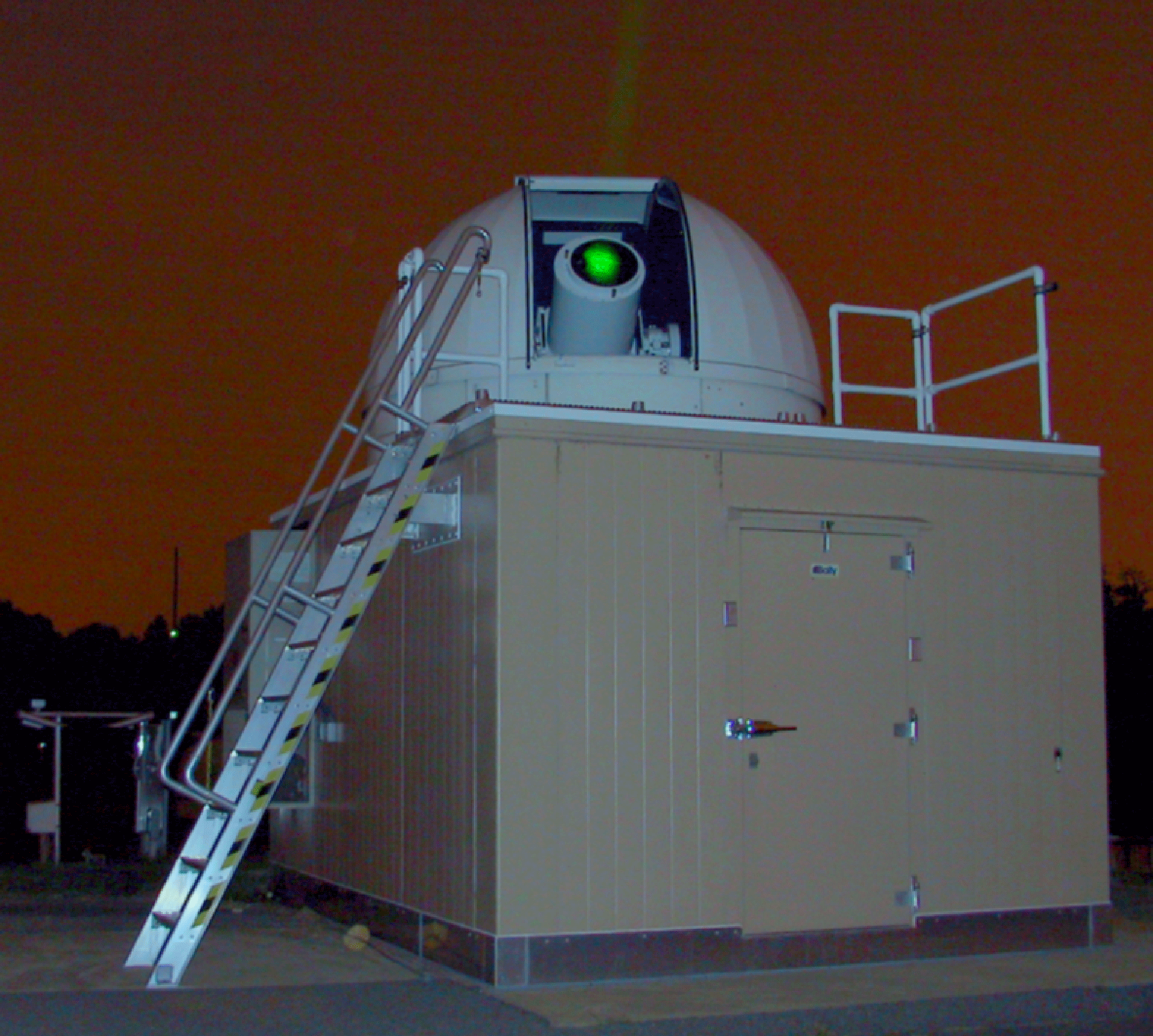
NGSLR performing nightime ranging at GGAO.
NASA’s prototype Next Generation Satellite Laser Ranging System (NGSLR) was built to demonstrate that a system using existing COTS technology can satisfy the performance requirements as an autonomous and eye-safe photon-counting SLR station with normal point precision at the mm level. The system is intended to provide continuous 24-hour tracking coverage of artificial satellites up to GNSS altitudes. NGSLR demonstrated the new technology and performance capability. Based on the NGSLR experience, specifications were written for the creation of the SGSLR production system that can be built by industry.
The NGSLR system operated in an engineering mode at the optical site at GSFC near MOBLAS-7. During engineering testing, NGSLR observed over the full range of capability for engineering, diagnostic, and operational testing, during both nighttime and daylight conditions.
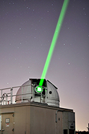
In 2013 NGSLR successfully ranged to a majority of the ILRS satellite constellation, demonstrating its ability to perform day and night ranging to most of the LEO, LAGEOS, LARES, and many of the GNSS satellites. In July 2013, NGSLR completed a successful five-week co-location with the NASA SLR network standard, MOBLAS-7. During the co-location, NGSLR demonstrated its ability to perform day and night tracking to satellites from LEO to GNSS altitudes. The NGSLR / MOBLAS-7 collocation was a highly successful verification of the performance of the NGSLR system. The final comparison results followed the expected differences between single and multi-photon systems and proved that the NGSLR system is a viable SLR system that meets the next generation SLR standards.
Today, NGSLR remains in an engineering status as SGP SLR focus is directed to the construction of the SGSLR.
- 1.2 meter (48") telescope: The GGAO multi-user 1.2-meter (48”) telescope facility is used for system testing and development of next generation satellite laser ranging systems.
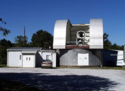
1.2 meter (48") telescope at GGAO.
The GGAO multi-user 1.2-meter (48”) telescope facility is used for system testing and development of next generation satellite laser ranging systems. Some of these systems use dual wavelength picosecond pulse-width lasers and picosecond resolution streak cameras to make absolute corrections for atmospheric refraction effects at the few millimeter level.
This multi-user facility was built in 1973-74 time period. It contains an arc-second precision tracking telescope and has supported many GSFC experiments
- In May, 2005, ranging to MLA (Mercury Laser Altimeter) onboard MESSENGER (MErcury Surface, Space ENvironment, GEochemistry and Ranging) Earthlink 2-Way Laser Ranging, at distance of 24 Mkm, exchanging laser pulses while the two systems were millions of miles apart; first successful two-way exchange of laser signals over a large distance from Earth and demonstrated sub-nanosecond timing accuracy.
- Mars Orbiter Laser Altimeter (MOLA) Earthlink 1-Way Laser Ranging, MOLA onboard MGS orbiting Mars at ~80 Mkm (Sep 2005)
- Periodic on-orbit calibrations of the Lunar Orbiter Laser Altimeter (LOLA) onboard LRO
- LOLA on-orbit calibration, 2-way laser ranging: (Aug & Sep 2009)