2022 Project News
 NASA Delivers First Flight Hardware to ESA for Lunar Pathfinder
12/02/2022NASA delivered the first flight hardware for the Lunar Pathfinder mission to ESA (European Space Agency), which formally accepted the instrument on Nov. 4. NASA's Goddard Space Flight Center in Greenbelt, Maryland, developed the instrument, a laser retroreflector array, which will test new navigation techniques for lunar missions.
NASA and ESA plan to launch Lunar Pathfinder via a future Commercial Lunar Payload Services delivery. In addition to testing navigation capabilities, Lunar Pathfinder will operate as a commercial communications relay satellite and provide communications services for exploration missions on the lunar surface.
The Lunar Pathfinder mission is led by Surrey Satellite Technology Ltd (SSTL), and ESA arranged for the mission to provide communications services to NASA. NASA Space Geodesy Project Manager Stephen Merkowitz, along with teams from ESA and SSTL, completed inspections when the laser retroreflector array arrived at SSTL's facility in Guildford, U.K., where it will be installed in the satellite.
Read more on nasa.gov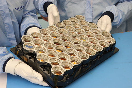
NASA's laser retroreflector array arriving for inspection and approval (Credit: Surrey Satellite Technology Ltd.)
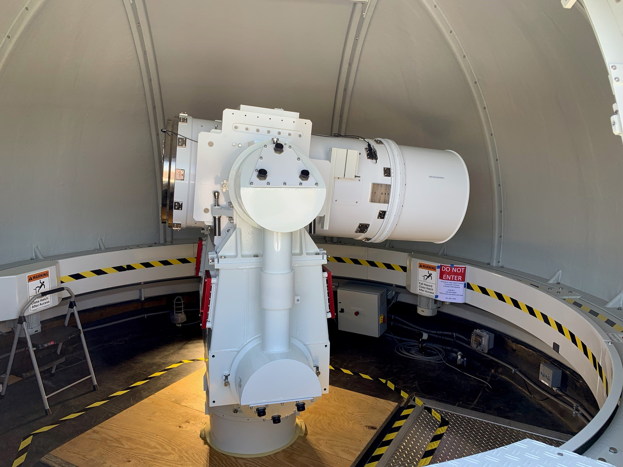
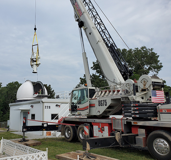
 Gimbal and Telescope Assembly (GTA) #1 installed in the SGSLR shelter in late June 2022
09/14/2022The Gimbal with Mass Simulator was removed from the GGAO SGSLR facility in June 2022 and shipped back to Cobham. After the Factory Acceptance Test at Cobham in Lansdale, the Gimbal and Telescope Assembly (GTA) #1 was shipped to GGAO and installed in the SGSLR shelter in late June 2022. Preparations for the Site Acceptance Testing (SAT) were begun shortly after installation.

GTA#1 in the SGSLR dome at GGAO.
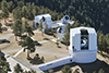
- Ny-Ålesund SGSLR dome hydraulic pump successfully replaced
09/14/2022The Ny-Ålesund SGSLR dome hydraulic pump was successfully replaced in August 2022 by Baader Planetarium as warranty work. The original pump was replaced with one that has a larger motor and does not require a heating element. Continued testing post-installation indicates that this replacement pump is working well.
 Shortest day in modern times
08/12/2022As noted in social media and the press (for example, here), the Earth recently experienced its shortest day in modern history. The length of day (LOD) of June 29, 2022 was recorded with 1.59 ms shorter than a standard 24-hour day (86,400 SI seconds). While this is a record in the era of atomic clocks (since the 1960s), it is nothing out of the extraordinary. LOD fluctuates over time and there were local minima in recent years as well. What is surprising is the fact that the Earth was speeding up a bit. In general terms, the Earth is slowing down mostly due to tidal friction caused by the moon: tidal bulges slow down the rotation of the Earth. For that, leap seconds are inserted to account for the slowed rotation. The currently observed increased rotational speed may be attributed to different geophysical phenomena, by themselves or in combination, including post-glacial rebound effects following the melting of ice masses particularly in the polar regions (including both recent ice mass loss as well as the long-term loss since the Pleistocene), climatological impacts on global hydrology due to recent consecutive La Nina events and changes in the parameters of the Earth's Chandler wobble (see articles here and here). On geological time scales (millions of years), however, the Earth has seen much shorter days (minutes to hours). Also, pre-atomic clock era LOD derivations using telescopic data from lunar occultations of stars point at around 2 ms shorter days in the 1870s, though with a much larger uncertainty. Hence, June 29, 2022 was not the shortest day ever in the history of the Earth but the shortest day in recent modern times. Monitoring these changes in the Earth's rotation is a critical function of the NASA Space Geodesy Project and its international partners as the changes are often unpredictable and provide key information about the geophysical changes affecting the Earth system (solid Earth, hydrosphere and atmosphere) and support precise positioning, satellite navigation, and the definition and maintenance of the Terrestrial Reference Frame.
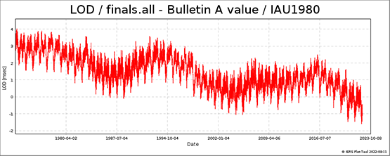
The time history of LOD from space geodesy measurements since 1975 are available from the IERS here.
 The twelfth session of the United Nations Committee of Experts on Global Geospatial Information Management (UN-GGIM) was held August, 3-5 2022
08/02/2022The twelfth session of the United Nations Committee of Experts on Global Geospatial Information Management (UN-GGIM) was held August, 3-5 2022 at the United Nations Headquarters in New York. The session brought together senior officials and executives from national geospatial information and statistical authorities within Member States, and international geospatial experts from across the globe. Several NASA personnel from the Space Geodesy Program participated in support of the UN-GGIM Subcommittee on Geodesy. Dr. Karen St. Germain, the Earth Science Division Director at NASA Headquarters, presented "the critical role that geodesy and the global observatories play in Earth observation" during the Forum on Global Geodetic Reference Frame for Sustainable Development. The recording of Dr. St. Germain's presentation is available here.
 NASA Mirrors on ESA Pathfinder to Empower Space Geodesy
07/08/2022NASA will supply the upcoming European Space Agency (ESA) Lunar Pathfinder mission with an array of laser retroreflectors, mirrored devices that reflect light back at its source. The retroreflectors will offer new opportunities for lunar science and space geodesy.
 NASA Mirrors on ESA Pathfinder to Enhance Lunar Navigation
07/08/2022NASA will supply the upcoming European Space Agency (ESA) Lunar Pathfinder satellite with an array of laser retroreflectors, mirrored devices that reflect light back at its source. The retroreflectors will validate navigation capabilities that will be critical to the Artemis missions and future lunar exploration.
 The Space Geodesy Project completed the Factory Acceptance Testing (FAT) of SGSLR's Gimbal and Telescope Assembly Unit #1 (GTA#1)
06/27/2022The Space Geodesy Project completed the Factory Acceptance Testing (FAT) of SGSLR's Gimbal and Telescope Assembly Unit #1 (GTA#1) in early June 2022 at the manufacturer's facility (Cobham Advanced Electronic Solutions in Lansdale PA). After passing the FAT Review GTA#1 was then shipped to GGAO on June 21st and installed in the SGSLR facility on June 22nd by the prime SGSLR contractor, KBR, Inc. KBR and Cobham are currently preparing the gimbal and optics to start the Site Acceptance Testing (SAT).
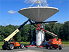 New Jackscrew Successfully Installed on GGAO VGOS Antenna
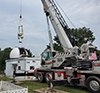
06/17/2022A new jackscrew and gearbox assembly were installed on the 12m VGOS antenna system at NASA Goddard Geophysical Astronomical Observatory (GGAO) in Greenbelt, Maryland during the week of June 6 – 10, 2022. The GGAO site operations and engineering management team from Peraton, antenna repair technicians from Intertronics Solutions, Inc. (ISI) – Calian and heavy equipment operations personnel from United Rigging in Beltsville, Maryland supported the repair activities. Replacement of the jackscrew improves overall structural and motion integrity associated with antenna pointing requirements and promotes continuous VLBI scientific research contributions from the NASA/SGP network.
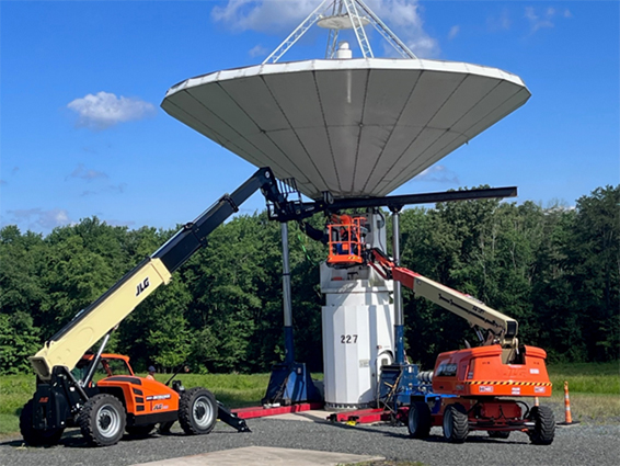
ISI-Calian engineering technician inspects installation of new jackscrew beneath the GGAO 12m dish supported by a horizontal metal beam and hydraulic gantry system as required by NASA safety guidelines.
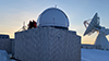 The Space Geodesy Project completes the installation of the dome, riser, and optical bench support structure for the new NASA Space Geodesy Satellite Laser Ranging (SGSLR) station at Ny-Ålesund, Svalbard
05/18/2022The Space Geodesy Project completed the installation of the dome, riser, and optical bench support structure for the new NASA Space Geodesy Satellite Laser Ranging (SGSLR) station at Ny-Ålesund, Svalbard. The installation was performed by members of the SGSLR KBR team and the dome manufacturer Baader Planetarium, along with support from the Norwegian Mapping Authority and King's Bay AS. The Norwegian Mapping Authority hosted a Geodesy Event at Ny-Ålesund for Norwegian and United Nations dignitaries to celebrate this milestone. Dr. Karen St. Germain (NASA Earth Science Division Director) gave a public lecture on "The critical role that geodesy and the global observatories play in Earth observation" at the event and Stephen Merkowitz (Space Geodesy Project Manager) served on a discussion panel. The Norwegians also produced a short video for the event: Geodesy at the top of the world.

Dr. Karen St. Germain controlled the new SGSLR dome at the Geodesy Event in Ny-Ålesund.
 First year of Apache Point Lunar Laser Ranging data released under NASA stewardship
02/11/2022In 2021, the Apache Point Lunar Laser Ranging station became part of the NASA Space Geodesy Network with New Mexico State University responsible for the on-site day-to-day operations and maintenance of the system. Over the past year, the NASA team worked with the former APOLLO team to establish best practices regarding observation and reduction of raw data into normal points, including the development of a new quality control process to identify centimeter-level biases in lunar laser ranging data. The new process helps to eliminate erroneous normal points and systematic biases prior to data publication. NASA Postdoctoral Fellow Nicholas Colmenares (one of the primary members of the former APOLLO group) led the development of the data procedures and archival of the data in the new version 2 of the Consolidated Range Data (CRD) format. The full set of 2021 data is now available from the Crustal Dynamics Data Information System (CDDIS) at https://cddis.nasa.gov/Data_and_Derived_Products/SLR/Lunar_laser_ranging_data.html.
 The passing of Professor George Veis
01/31/2022It is with great sadness that we convey the passing of George Veis, scientist, teacher, and a good friend to all of us; truly one of the fathers of Space Geodesy.
George was born in Athens in 1929. In 1951 he graduated in Surveying Engineering from the National Technical University of Athens (NTUA). In 1955 he was the recipient of a Greek state fellowship for advanced studies in Paris at the Sorbonne and the Ecole Nationale des Sciences Geographiques. He then spent some time at the Observatoire de Paris and the Bureau Gravimetrique International. Starting in 1957 he continued his postgraduate studies at the Ohio State University, where he was awarded with his PhD in 1958, after defending his famous dissertation on the "Geodetic Applications of Observations of the Moon, Artificial Satellites and Rockets".
George was one of the framers of the early Satellite Geodesy Program at the Smithsonian Astrophysical Observatory, which itself was a fundamental element of the early NASA Space Geodesy Activity.
George joined the Smithsonian Astrophysical Observatory (SAO), (later the Harvard Smithsonian Center for Astrophysics) in 1959 at the beginning of satellite geodesy era and the deployment of the Baker Nunn Satellite Tracking Cameras for geodetic and other scientific research. Over two decades as principal scientific consultant at SAO, he helped guide activities as the satellite geodesy program evolved with the Baker Nunn Camera and the emergence of Satellite Laser Ranging (SLR). He worked with the engineers on the design of the SAO SLR systems and the retroreflectors on satellites.
While at SAO, George contributed the early concept and evolution of the Differential Orbit Improvement (DOI) Program, which became the main analysis tool for satellite tracking, geopotential estimation, station coordinate determination, and satellite drag research. He defined the fundamental reference system used for many years, which now forms the basis of modern models of earth rotation, precession, and nutation. He also initiated the SAO Star Catalogue project, which provided a uniform all-sky catalogue for precision camera observations, and was used for many years all over the world.
Keeping his connection with SAO, George returned to NTUA, where he was elected Professor of Surveying (renamed later Higher Geodesy and Cartography) to develop satellite geodesy in Greece.
In 1969 he established the tracking station at Dionysos, installed a Baker-Nunn camera there, and began developing a laser ranging system. He had the vision of a complete geophysical observatory with, of course, satellite tracking, a meteorological observatory, earth tide monitoring, strain gauges, etc. He also developed surveys based on Transit Doppler measurements and GPS when the equipment became available. As an early mobile SLR deployment, George transported the Dionysos laser system to the remote island of Othoni, north of Corfu, Greece, and used it in October of 1973 to measure the distance to an Italian target at Specchia, Cristi at the tip of the boot. This measurement enabled for the first time the accurate connection of the Greek geodetic network with main Europe (Balodimos D., Geodetic Connection between Greece and Italy, Anno xxxvi, Bollettino di Geodesia e scienze Affini, 1977).
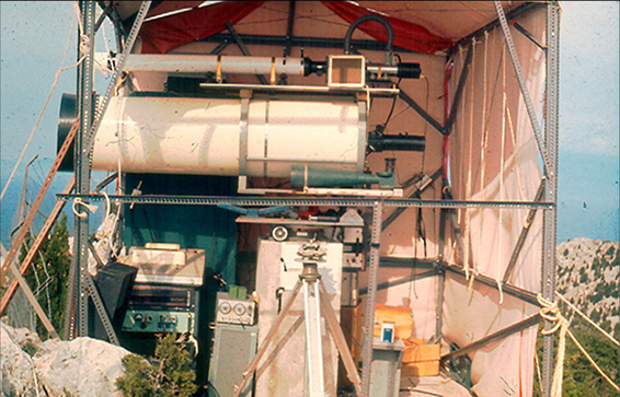
Dionysos laser system deployed on the island of Othoni northeast of Corfu, Greece, in October of 1973 (D. Balodimos personal archive).
George's department at NTUA was a major source of young geodesists for the global community.
The Dionysos station contributed to the MERIT, MEDLAS, WEGENER and other programs. Between 1965 and 1984 George also organised the famous series of international symposia, in Lagonissi and Athens, on the "Use of Artificial Satellites for Geodesy and Geodynamics". The five volumes of the proceedings of these symposia document a great part of 20 years of geodetic history.
George's career as a science-administrator was also rich. As a member of the NTUA's senate and the Dean of the Faculty of Surveying Engineering, he suffered a short, but painful imprisonment by the military dictatorship in Greece, because of his proper academic comportment during students protest which caused the furious reaction of the regime. He was the Secretary General of the Hellenic Committee for Geodesy and Geophysics, its President from 1982 to 1990. He was President of the Board of the Athens National Observatory and the President of the Observatory's Scientific Council. He was the President of the Cadastre and Mapping Organization of Greece and the President of the National Consultative Council for Research. He also presided over several IAG/IUGG and COSPAR organizations. George retired from the NTUA in 1997. The ETH of Zurich honored him with an Honorary Doctor's degree.
George continued to be active in a key position as the President of the important Supreme Council for Personnel Selection, a state authority responsible for the selection of personnel for the public administration in Greece. George was awarded the Levallois Medal in 2003 in recognition of his distinguished service to the science of geodesy.
George Veis continued to be endlessly creative, engaging, seducing, elegant, modern and forever young scientist, who shared his ideas with enthusiasm, and helped everyone with whom he had contact. He witnessed the birth of space geodesy, its evolution from many meters to mm's, and continued to think about its future until his death. He had celebrated his 92nd birthday last September 8th, 2021.
George is survived by his wife Katerina, and children Konstandinos, Alexandros, Ino, Nico and Maria, and his grandchildren. His funeral is set for January 31, at noon.
May his memory be an abiding blessing.
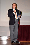
George Veis during his last visit to the USA in 2014, while attending the ILRS Annapolis Workshop.