2021 Project News
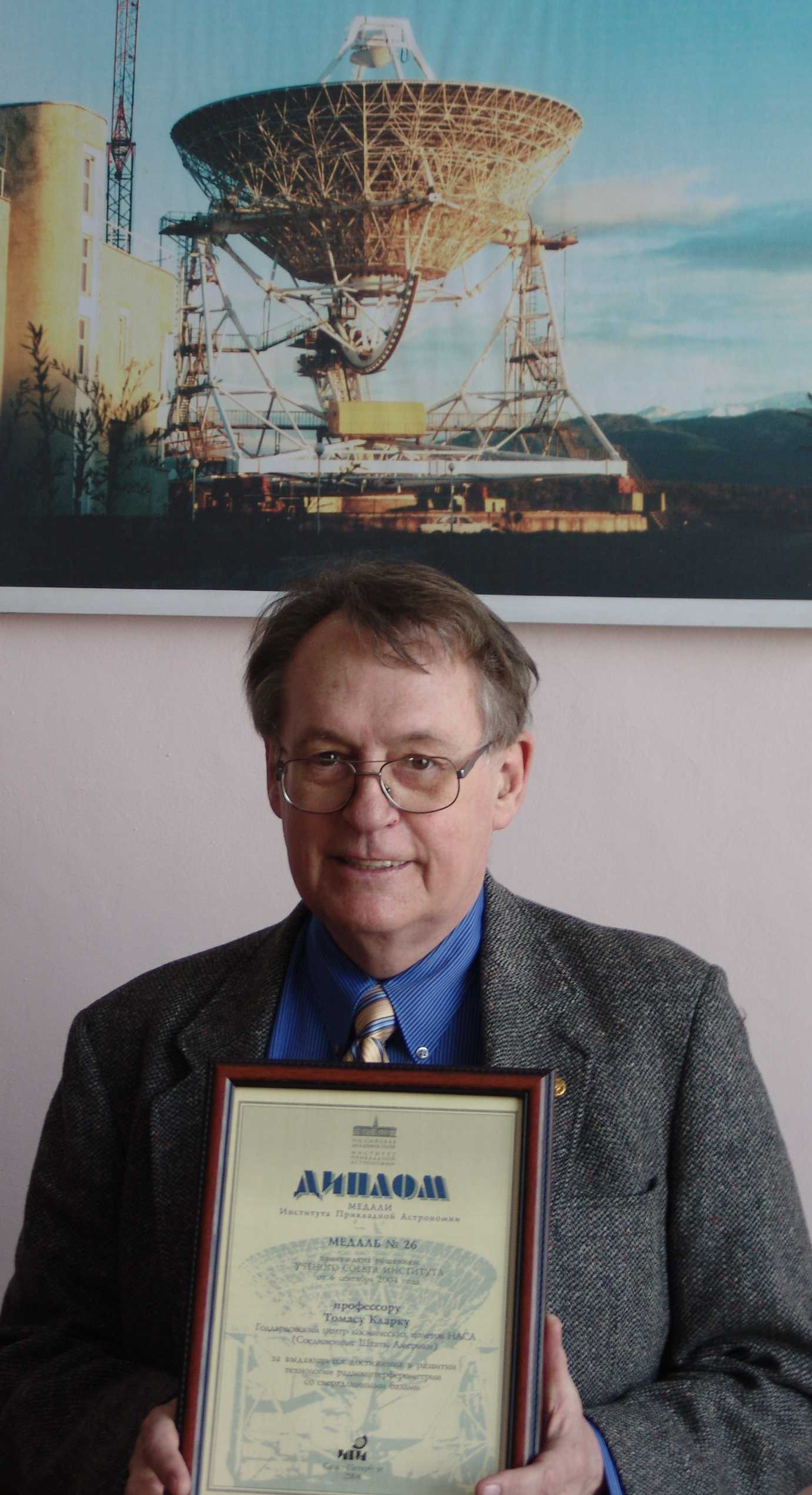
 The passing of Thomas Clark
10/05/2021Space Geodesy lost a longtime colleague and friend with the passing of Thomas Arvid Clark on September 28, 2021. Tom was a pioneer in Space Geodesy and Very Long Baseline Interferometry (VLBI), and a founding member of the NASA Crustal Dynamics Project.
Tom received his B.S. in Engineering Physics and his Ph.D. in Astro-Geophysics from the University of Colorado in 1961 and 1967 respectively. From 1966 to 1968, he served as Chief of the Astronomy Branch at NASA Marshall Space Flight Center and as Project Scientist on the Spacelab Coronagraph. At GSFC, where he moved in 1968, Tom received numerous NASA awards for his pioneering work on Radio Astronomy Explorer 1 and 2 and several generations of Very Long Baseline Interferometry systems. Tom developed the Totally Accurate Clock (TAC), an inexpensive GPS timing receiver that found widespread use in a number of global networks. Tom was named a Fellow of the American Geophysical Union (AGU) in 1991 and a Fellow of the International Association of Geodesy (IAG) in 1999. Tom was also a pioneer in amateur and digital radio; he designed and flew several low cost satellites for relaying amateur radio messages around the globe and is a past president of AMSAT. He was one of only 50 initial inductees into the CQ Amateur Radio Hall of Fame, a list which included such engineering luminaries and inventors as Guglielmo Marconi (radio), Samuel Morse (telegraph), Nikola Tesla (HF generators and radio), and John Bardeen and William Schockley (transistor). Tom retired from GSFC in 2001 but remained active in Amateur Radio activities.
Those of us who worked with Tom during the Crustal Dynamics period remember him as a brilliant mind, a very interesting and sometimes caustic character, but someone who was kind, supportive, and very helpful to those of us around him. We will miss him. ILRS Virtual World Tour 2021 third circular released
08/31/2021Dear Colleagues:
We look forward to seeing you at "ILRS Virtual World Tour 2021". Progress has been made at the five tour hosts and by the session chairs. Now we have just opened the registration form. Please visit the event website below and find the link.
https://ilrs.gsfc.nasa.gov/ILRS_Virtual_World_Tour_2021/index.html
Registration period: October 1 to 15, 2021
Participants are encouraged to register as a group if possible, due to the limit of Microsoft Teams individual participants allowed. The URL links will be sent only to the registered people.
See you in a month!
ILRS Virtual World Tour 2021 Organizers:
Claudia Carabajal/SSAI, Inc, NASA Goddard Space Flight Center, USA
Evan Hoffman/NASA Goddard Space Flight Center, USA
Igor Ignatenko/VNIIFTRI, Russia
Jason Laing/Peraton NSGN Operations Lead, USA
Toshimichi Otsubo/Hitotsubashi University, Japan (Chair)
Michael Pearlman/ Harvard-Smithsonian Center for Astrophysics, USA
Ulrich Schreiber/Geodetic Observatory Wettzell, Germany
Zhang Zhongping/Shanghai Astronomical Observatory, China- ILRS Virtual World Tour 2021 second circular released
08/31/2021Dear Colleagues:
We are happy to report the updates on this year's "ILRS Virtual World Tour". In addition to the virtual visits to the stations (∼120 min), short special add-on sessions (30-60 min) are planned with the help of the Standing Committee Chairs. We look forward to seeing you in the last week of October.
Schedule (tentative; in UTC):
Monday, October 25
12:00 Opening session with reports from ILRS CB and Geodetic Community
12:45 Virtual Tour of Herstmonceux, UK
Tuesday, October 26
13:00 Virtual Tour of Wettzell, Germany
15:00 Special Session on Network & Engineering, LLR and Space Debris Ranging
Wednesday, October 27
13:00 Virtual Tour of Mendeleevo, Russia
15:00 Special Session on Analysis
Thursday, October 28
06:00 Virtual Tour of Shanghai, China
08:00 Special Session on Missions (1)
Friday, October 29
16:00 Virtual Tour of Monument Peak, USA
18:00 Special Session on Data Format and Missions (2), and Closing
Workshop website: https://ilrs.gsfc.nasa.gov/ILRS_Virtual_World_Tour_2021/index.html
Logistics:
Microsoft Teams will be used for all of these sessions.
The Third Circular will be issued later with details on registration.
ILRS Virtual World Tour 2021 Organizers:
Claudia Carabajal/SSAI, Inc @ NASA Goddard Space Flight Center, USA
Evan Hoffman/NASA Goddard Space Flight Center, USA
Igor Ignatenko/VNIIFTRI, Russia
Jason Laing/Peraton NSGN Operations Lead, USA
Toshimichi Otsubo/Hitotsubashi University, Japan (Chair)
Michael Pearlman/Center for Astrophysics, USA
Ulrich Schreiber/Geodetic Observatory Wettzell, Germany
Zhang Zhongping/Shanghai Astronomical Observatory, China
 The Rector of the University of San Augustin in Arequipa, Peru, Dr. Rohel Sánchez Sánchez, visited the Instituto Astronómico y Aeroespacial Pedro Paulet (IAAPP) and the TLRS-3 Station
08/26/2021The Rector of the University of San Augustin in Arequipa, Peru, Dr. Rohel Sánchez Sánchez, visited the Instituto Astronómico y Aeroespacial Pedro Paulet (IAAPP) and the TLRS-3 Station to commemorate legalizing UNSA ownership of the property that has been used by USNO to support NASA and other research activities for the past 62 years. The Manager of the TLRS-3 Station, Dr. P. Raul Yanyachi, is also featured in the video posted by UNSA TV on social media.
Watch video on social media Dan O'Gara retired after 37 years of dedicated support to the International Geodetic Community
05/12/2021The International Laser Ranging Service (ILRS) and the NASA Space Geodesy Project (SGP) express our appreciation and congratulations to Dan O'Gara for his 37 years of service to the international geodetic community. Dan retired from the University of Hawaii (UH) on April 30, 2021.
Much of Dan O'Gara's work at UH was with the Lunar Ranging Experiment (LURE) observatory. The University of Hawaii's LURE was installed on Haleakala in 1973. Dan joined the team in the early 1980s, performing maintenance and developing the software to control the LURE beam director and operating the system. The station became known as HOLLAS by the ILRS community as it gained the capability to track satellites and took on the 4-character code of HALL (for Haleakala Laser), but the locals always referred to it as LURE. Dan eventually became the station manager for LURE while he continued to develop the software and operate the system.
See https://ilrs.gsfc.nasa.gov/network/stations/inactive/HALL_station_info.html and http://koa.ifa.hawaii.edu/Lure/#:~:text=The%20Lure%20Observatory%20is%20located,Maui%20in%20the%20Hawaiian%20archipelago.&text=The%20Lunar%20Ranging%20Experiment%20(LURE,and%20reflectors%20on%20the%20Moon
The LURE facility was decommissioned in 1990 to make room for another experiment. In 2006, NASA installed the TLRS-4 Satellite Laser Ranging station at a different location on the top of the mountain. Dan continued his work as station manager, operator, and laser ranging software expert for TLRS-4.
Dan is well known and liked by everyone in the ILRS and SGP. He continued his interest in the lunar community even after the UH lunar laser ranging program ended. He participated in multiple ILRS Workshops including the Workshop in Annapolis which celebrated the 50th anniversary of SLR. He hosted numerous site visits to Haleakala by many groups and supported the Space Geodesy Project's preliminary work to deploy a next generation SLR station and new GNSS stations on the top of Haleakala, helping the SGP team find a good location for the new SLR system and supporting the team's site visit in 2015.
The Maui SLR stations have played a critical role in the international SLR network by covering satellite tracking over the Pacific. The station team under the leadership and management of Dan O'Gara has done a great job. His calm demeanor and sense of humor has been much appreciated.
Dan was the face of Hawaii laser ranging for many decades. He will be greatly missed by his colleagues and friends in the Space Geodesy Project and the International Laser Ranging Service. We wish Dan a healthy and happy retirement, and great success in his future plans!
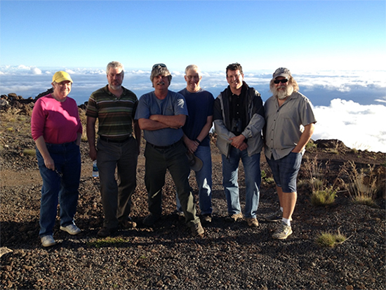 Dan O'Gara, featured at the center of the picture, accompanied by SGP folks during a site visit in 2015. From left to right: Jan McGarry, Stephen Merkowitz, Dan O'Gara, Jim Long, Scott Wetzel, and David Stowers. (Photo credit: Scott Wetzel)