2015 Project News
-
 Brief network outages at GSFC on December 19, 2015
12/11/2015 Work will be performed on the NASA GSFC network infrastructure from 03:00 p.m. (20:00 UTC), Saturday, December 19, 2015 through 03:00 a.m. (08:00 UTC) on Sunday, December 20. Users can expect 10-15 minute interruptions during that time period.
Should the CDDIS be unaccessible, users can access one of the other data centers supporting the services:
We regret any problems this work may cause the user community
-
 New "Site Requirements for GGOS Core Sites" document released
12/02/2015 Version 2 of the document Site Requirements for GGOS Core Sites has been issued.
-
 Space Geodesy VLBI Antenna Request for Information Released
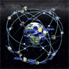
10/06/2015 The National Aeronautics and Space Administration (NASA) Space Geodesy Project (SGP) is soliciting information to improve its understanding of the interest, capabilities, and Rough Order of Magnitude (ROM) estimates for planning the construction and deployment of up to three Very Long Baseline Interferometer (VLBI) antennas that will be part of a new NASA Space Geodesy Network (NSGN) and the VLBI2010 Global Observing System (VGOS).
 Read more
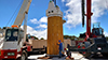 KPGO blogRelease Date: 09/04/2015
The Space Geodesy Project is pleased to announce a new blog. This blog follows the implementation of the Space Geodesy Project’s new 12-meter broadband Very Long Baseline Interferometry (VLBI) station at NASA’s Kōkeʻe Park Geophysical Observatory (KPGO) on Kauai, Hawaii. The new station is a joint effort by NASA Goddard Space Flight Center and the United States Naval Observatory, and will become part of the VLBI2010 Global Observing System (VGOS). The station design is based on the successful prototype VLBI2010 station at NASA’s Goddard's Geophysical and Astronomical Observatory (GGAO) in Greenbelt, MD. The new KPGO antenna was developed by Intertronics Solutions, Inc. (ISI), and the MIT Haystack Observatory is responsible for the development of the broadband signal chain.
KPGO blogRelease Date: 09/04/2015
The Space Geodesy Project is pleased to announce a new blog. This blog follows the implementation of the Space Geodesy Project’s new 12-meter broadband Very Long Baseline Interferometry (VLBI) station at NASA’s Kōkeʻe Park Geophysical Observatory (KPGO) on Kauai, Hawaii. The new station is a joint effort by NASA Goddard Space Flight Center and the United States Naval Observatory, and will become part of the VLBI2010 Global Observing System (VGOS). The station design is based on the successful prototype VLBI2010 station at NASA’s Goddard's Geophysical and Astronomical Observatory (GGAO) in Greenbelt, MD. The new KPGO antenna was developed by Intertronics Solutions, Inc. (ISI), and the MIT Haystack Observatory is responsible for the development of the broadband signal chain.
 Michael Pearlman awarded the 2014 Golden Medal of MeritRelease Date: 08/28/2015
In April 2015, Michael Pearlman, Director of the ILRS Central Bureau, was awarded the 2014 Golden Medal of Merit by the Scientific Board of the Institute of Applied Astronomy of the Russian Academy of Sciences in recognition of his achievements and contributions in laser ranging and international scientific programs. The citation for the award read: "For outstanding contribution to the development of space geodesy and for promoting the IAA RAS role in creation and enhancement of GGOS." Mike visited the Institute of Applied Astronomy in Saint Petersburg in April and accepted the award during a ceremony in conjunction with the 6th All-Russian Meeting "Fundamental and Applied Positioning, Navigation and Timing" (PNT-2015). Mike also participated in the conference and gave a talk titled, "The Global Geodetic Observing System (GGOS) and the Important Role played by the Institute of Applied Astronomy, ROSCOSMOS, and other Russian Participants."
Michael Pearlman awarded the 2014 Golden Medal of MeritRelease Date: 08/28/2015
In April 2015, Michael Pearlman, Director of the ILRS Central Bureau, was awarded the 2014 Golden Medal of Merit by the Scientific Board of the Institute of Applied Astronomy of the Russian Academy of Sciences in recognition of his achievements and contributions in laser ranging and international scientific programs. The citation for the award read: "For outstanding contribution to the development of space geodesy and for promoting the IAA RAS role in creation and enhancement of GGOS." Mike visited the Institute of Applied Astronomy in Saint Petersburg in April and accepted the award during a ceremony in conjunction with the 6th All-Russian Meeting "Fundamental and Applied Positioning, Navigation and Timing" (PNT-2015). Mike also participated in the conference and gave a talk titled, "The Global Geodetic Observing System (GGOS) and the Important Role played by the Institute of Applied Astronomy, ROSCOSMOS, and other Russian Participants."
 Third GNSS Tracking CampaignRelease Date: 08/05/2015
The third SLR GNSS Tracking Campaign will run from August 10 through October 16 (10 weeks). The focus will be on the following GNSS satellites:
Third GNSS Tracking CampaignRelease Date: 08/05/2015
The third SLR GNSS Tracking Campaign will run from August 10 through October 16 (10 weeks). The focus will be on the following GNSS satellites:
- GLONASS-123, -125, -128, -129, -133, and -134
- Compass-M3
- Galileo-101, -102, -103, and -104
The revised priority list reflecting these changes for the third campaign is now available on the ILRS website at: https://ilrs.gsfc.nasa.gov/missions/mission_operations/priorities/index.html. The results from this campaign will be a topic of discussion at the upcoming ILRS Technical Workshop to be held October 26 - 30 in Matera (http://geodaf.mt.asi.it/2015_ILRS_TW/index.html).
- Results from Second GNSS Tracking CampaignRelease Date: 07/31/2015
The second GNSS Tracking Campaign was held November 28, 2014 through February 28, 2015. To keep the document at a manageable size, it focuses on the 14 most productive sites in this campaign. The report can be accessed on the activities link in the LARGE Study Group section of the ILRS website.
Read more...
 CDDIS Earthdata webinar, "Distributing Real-Time GNSS Data and Derived Products at the CDDIS"Release Date: 07/22/2015
The CDDIS held an Earthdata webinar titled, "Distributing Real-Time GNSS Data and Derived Products at the CDDIS". This webinar provides an overview of the Global Navigation Satellite System (GNSS), the International GNSS Service (IGS), Real-time GNSS, the CDDIS real-time data caster and protocol, the registration process before accessing the real-time data, and several demonstrations on configuring and using the client software.
CDDIS Earthdata webinar, "Distributing Real-Time GNSS Data and Derived Products at the CDDIS"Release Date: 07/22/2015
The CDDIS held an Earthdata webinar titled, "Distributing Real-Time GNSS Data and Derived Products at the CDDIS". This webinar provides an overview of the Global Navigation Satellite System (GNSS), the International GNSS Service (IGS), Real-time GNSS, the CDDIS real-time data caster and protocol, the registration process before accessing the real-time data, and several demonstrations on configuring and using the client software.
 ILRS Technical Workshop (26-30 October 2015, Matera, Italy) Abstract SubmissionRelease Date: 07/20/2015
Author: Cinzia Luceri/Giuseppe Bianco
ILRS Technical Workshop (26-30 October 2015, Matera, Italy) Abstract SubmissionRelease Date: 07/20/2015
Author: Cinzia Luceri/Giuseppe Bianco
At the next ILRS Technical Workshop (26-30 October 2015, Matera, Italy) session chairs will designate key people to present position papers to introduce topics and set the scene for discussion. Abstracts for these position papers must be submitted through the abstract submission process. Other abstracts may be submitted for oral and poster presentations. Oral presentations must be relevant to a particular session and address some of the key questions identified in the session description. Oral presentations will go through an approval process by session chairs so they can plan an orderly program including sufficient time for discussion. Presentations should be short and informative. All presentations not accepted for oral talks may be given as posters. We view posters as a very important part of the meeting; they provide one-on-one opportunity for discussion on key features of the papers. Participants are welcome to submit abstracts for any or all sessions.
We need broad participation in the session discussions. In addition to the scheduled talks, participants are encouraged to bring one or two charts to stress or support particular points and issues in the discussion. Look carefully at the questions listed for each session. These charts will be uploaded before each session but do not require a submitted abstract. The Session Chairs will coordinate this activity. All charts will be included in the workshop proceedings.
The opportunity to submit abstracts is now open, deadline September 30th, 2015.
Please, use the conference website
http://geodaf.mt.asi.it/2015_ILRS_TW/itwl_abstract.htm NASA Explains Why June 30 Will Get Extra SecondRelease Date: 06/26/2015 The day will officially be a bit longer than usual on Tuesday, June 30, 2015, because an extra second, or "leap" second, will be added.
"Earth's rotation is gradually slowing down a bit, so leap seconds are a way to account for that," said Daniel MacMillan of NASA’s Goddard Space Flight Center in Greenbelt, Maryland.
Strictly speaking, a day lasts 86,400 seconds. That is the case, according to the time standard that people use in their daily lives – Coordinated Universal Time, or UTC. UTC is "atomic time" – the duration of one second is based on extremely predictable electromagnetic transitions in atoms of cesium. These transitions are so reliable that the cesium clock is accurate to one second in 1,400,000 years.
However, the mean solar day – the average length of a day, based on how long it takes Earth to rotate – is about 86,400.002 seconds long. That's because Earth's rotation is gradually slowing down a bit, due to a kind of braking force caused by the gravitational tug of war between Earth, the moon and the sun. Scientists estimate that the mean solar day hasn't been 86,400 seconds long since the year 1820 or so.
This difference of 2 milliseconds, or two thousandths of a second – far less than the blink of an eye – hardly seems noticeable at first. But if this small discrepancy were repeated every day for an entire year, it would add up to almost a second. In reality, that's not quite what happens. Although Earth's rotation is slowing down on average, the length of each individual day varies in an unpredictable way.
Read more... The passing of Dr. Bob SchutzRelease Date: 06/11/2015We are sad to announce that our colleague and friend, Dr. Bob Schutz, University of Texas at Austin/Center for Space Research (CSR) passed away on June 7, 2015, surrounded by family.
Bob was a member of the faculty at the University of Texas since 1969. His research interests included space geodesy and its applications, space geodetic instrumentation, precise orbit determination, orbital mechanics, mission planning and computational techniques. He was the science team leader for NASA's Geoscience Laser Altimeter System (GLAS), an instrument used to measure topography, especially the changes in Antarctic and Greenland ice sheets, that operated on the Ice, Cloud, and land Elevation Satellite (ICESat) in Earth's orbit for seven years.
Bob was recently elected a member of the National Academy of Engineering (NAE), and he was a fellow of the American Institute of Aeronautics and Astronautics, the American Geophysical Union, and the American Astronautical Society. Most recently, he held the Joe J. King Chair in Engineering and the FSX Professorship in Space Applications and Exploration at the University of Texas at Austin. Bob was also a special friend of the IAG Services, participating in many activities over the years and giving advice both in the early days and through recent years. His IAG contributions including being a co-founder of the International Laser Ranging Service (ILRS), and being closely involved in the IGS (International GPS Service, now the International GNSS Service) since its inception in the early 1990s, serving most recently on the ILRS Governing Board.
Bob was a cherished colleague, a Ph.d advisor, mentor and a fine gentleman. His legacy will be appreciated for many years to come. We wish to pass on our condolences to Bob’s family, friends, and colleagues around the world. We will truly miss him.- NASA network connectivity outageRelease Date: 04/22/2015
Starting this Sunday, April 26, there will be a scheduled outage for NASA network connectivity, from April 26 17:00 UTC through April 27 05:00 UTC. We have been told that the NASA network will be unavailable during the first four hours; intermittent outages of several minutes can be expected after that time until the end of the period specified above. During the outage, the ILRS, CDDIS, and Space Geodesy Project websites will not be accessible.
While the CDDIS is unavailable, users can access one of the other data centers supporting the services:
IGS: https://igs.org/data-access/#global-dcs
IGS RTS: https://igs.org/rts/
ILRS: https://ilrs.gsfc.nasa.gov/data_and_products/data_centers/index.html (consult prior to outage)
IVS: http://ivscc.gsfc.nasa.gov/about/org/components/dc-list.html
IDS: http://ids-doris.org/data-products/info.html
We regret any problems this outage may cause the user community.
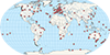 Real-Time GNSS Data and Products now available through the CDDISRelease Date: 04/10/2015
The CDDIS staff is pleased to announce that its real-time caster is now operational, supporting the International GNSS Service (IGS) Real-Time Service (RTS). The IGS RTS, based on a cooperative global infrastructure of stations, data centers, and analysis centers, provides GNSS orbit and clock corrections that enable precise point positioning (PPP) and related applications, such as time synchronization and disaster monitoring at global scales. The CDDIS caster utilizes the NTRIP (Networked Transport of RTCM via Internet Protocol) software to disseminate these real-time streams to registered users.
Real-Time GNSS Data and Products now available through the CDDISRelease Date: 04/10/2015
The CDDIS staff is pleased to announce that its real-time caster is now operational, supporting the International GNSS Service (IGS) Real-Time Service (RTS). The IGS RTS, based on a cooperative global infrastructure of stations, data centers, and analysis centers, provides GNSS orbit and clock corrections that enable precise point positioning (PPP) and related applications, such as time synchronization and disaster monitoring at global scales. The CDDIS caster utilizes the NTRIP (Networked Transport of RTCM via Internet Protocol) software to disseminate these real-time streams to registered users.
The CDDIS has incorporated the EOSDIS User Registration System (URS) to handle user signup and access authentication. At this time, the CDDIS is making real-time data available from 155 sites (see map) as well as 37 product streams. Future plans include the addition of more station data streams and computation and conversion of these data streams into high‐rate data files for the CDDIS online archive. More information about the CDDIS caster and real-time data and products is available from the CDDIS website: https://cddis.gsfc.nasa.gov/Data_and_Derived_Products/GNSS/real-time_data.html.