VTS Technique
Space geodetic techniques are now making measurements over global distances (100s to 1000s of km) to mm precision, but one of the fundamental problems with the co-location between techniques is the measurement of the vector between the invariant reference points on the co-located systems. Invariant points are almost always inaccessible (e.g., intersection of axes). The determination of these vectors normally includes a survey between accessible points on each instrument plus extrapolations to points that are not directly accessible. The goal of sub-mm accuracy may also require a monitoring component in order to account for real or near real-time local motion.
Current ground survey techniques can provide closure to properly configured ground monuments to mm accuracies, but these measurements tend to be both expensive and infrequent, and there is no guarantee of consistency between surveys done at very different times and in very different places. To take full advantage of the integrated nature of the next generation NASA Space Geodetic Stations, it will be necessary to implement an economical approach that will routinely measure and/or monitor the inter-system vectors. This monitoring must have sufficient spatial accuracy and temporal resolution to support requirements for the reference frame now projected at 1 mm accuracy and 0.1 mm/year stability.
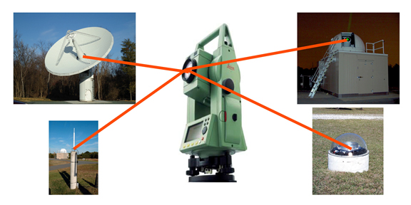
One promising modern approach is ground surveys using commercially available Robotic Total Station (RTS) survey systems and a local network of ground reference pillars. These instruments are programmable and should be operable by local personnel. The Goddard NASA VLBI group is currently performing a proof-of-concept study at the GGAO using a single RTS to evaluate the system for continuous monitoring of the vector ties between elements of the prototype station.
This work within SGP will include considering observational strategies, developing methodologies for VLBI and SLR systems which may incorporate an accessible reference point, and address issues related to site layout and delivery of vector tie data and data processing techniques. There are two different types of geodetic instruments, those with moving elements that point at a specific target at a particular time (SLR and VLBI) and those with omni-directional antennas and no moving parts (GNSS, DORIS). For SLR and VLBI the RTS will measure one or more targets on the telescope tube or antenna structure as the instrument moves to determine the location the geometric reference point related to the intersection of axes. For GNSS and DORIS the RTS measurement is to fixed points on the antenna from which the location of the reference point can be inferred from antenna geometry. It is essential that there be proper lines of sight to the geodetic instruments from the survey network, in particular into the radome enclosure of the SLR.
The site tie vector technique